A recent radio news piece about the redevelopment of an urban area brought to mind a term I first read during a college history course. Palimpsest may be used as a noun, verb or adjective and originally was used in reference to paper or other writing materials which were reused so that the original text was partially erased or obliterated and new text overlay the old. By the nineteenth century the term was used for things which similarly had been layered with something new but still had a trace of the original such as land and buildings.
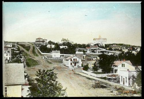
Take, for instance, the site of the oldest photographic image in
Nebraska Memories, “
View looking northwest from 15th and Douglas” (
Omaha Public Library Collection). The colorized lantern slide below is from about 1865 and shows Douglas Street from 15th Street to just past 18th Street in Omaha, then the Territorial capital of Nebraska. The roads are dirt (or mud), but houses and other buildings, including the Captiol building on the hill right of center, have been built and trees planted. When Omaha was established in 1854, the topography would have been the same with the land sloping upward from the Missouri River, but it would have been covered in prairie grass as far as the eye could see.
Millions of years ago, Omaha’s locale was close to a large inland sea when dinosaurs roamed the land. Later, glaciers shaped and re-shaped the lay of the land. But we don’t have any images of those times, so back to recorded history…
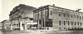
As Omaha grew, more businesses moved in and started replacing houses as shown in the image to the left (
15th and Douglas Streets, Omaha Public Library Collection). In the five years or so since the previous image was taken, building materials have already been upgraded to brick. The building on the corner which features extra architechtural detailing around the windows housed the City Livery stables.
In addition to new buildings, in the 1890s city officials changed the lay of the land with a re-grading project that lowered the steep rise in Douglas Street as seen in the first image. For more details and images, see
Re-Shaping Omaha.
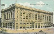
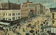
By the turn of the twentieth century, houses and trees have disappeared along this section of Douglas. “Downtown” businesses as shown in these two postcards from the Omaha Public Library Collection were being built to serve customers who lived farther out.
The
Brandeis Building, built in 1906 at 16th and Douglas Streets to house a department store and other businesses, is featured in the postcard to the left and is in the background of the postcard showing “
Douglas west from 15th, Omaha, Neb.” at right. However, what goes around comes around–the Brandeis Building now houses apartments and condominiums for those wishing to live downtown.
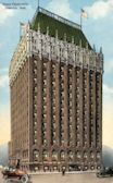
New buildings grew taller. Built in 1917, the
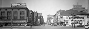
Hotel Fontenelle at 18th and Douglas Streets, shown in a postcard from the Omaha Public Library at left, had all the modern conveniences of the time. But it later changed its shape as seen (or not seen, as the top of the hotel has been changed) in the photograph at right taken from 17th and Douglas Streets in 1945 (
Omaha business district,
The Durham Museum collection). It would disappear totally from the landscape in 1983.
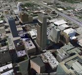
So, what does that northwest view from 15th and Douglas Streets look like today? If one of the first Omaha residents looked at the Google Earth snapshot at right, they would be totally astonished to see all of those buildings. But the hill that the territorial capitol sat on is still there; perhaps there are other features they would recognize too. Imagine what this area might look like one hundred years from now. We can only hope that someone takes and archives pictures over the decades so that others may see the changes that occur.
Visit
Nebraska Memories to search for or browse through many more historical images digitized from photographs, negatives, postcards, maps, lantern slides, books and other materials.
Nebraska Memories is a cooperative project to digitize Nebraska-related historical and cultural heritage materials and make them available to researchers of all ages via the Internet. Nebraska Memories is brought to you by the Nebraska Library Commission. If your institution is interested in participating in Nebraska Memories, see
http://nlc.nebraska.gov/nebraskamemories/participation.aspx for more information, or contact
Devra Dragos, Technology & Access Services Director.
 Millions of years ago, Omaha’s locale was close to a large inland sea when dinosaurs roamed the land. Later, glaciers shaped and re-shaped the lay of the land. But we don’t have any images of those times, so back to recorded history…
 As Omaha grew, more businesses moved in and started replacing houses as shown in the image to the left (15th and Douglas Streets, Omaha Public Library Collection). In the five years or so since the previous image was taken, building materials have already been upgraded to brick. The building on the corner which features extra architechtural detailing around the windows housed the City Livery stables.
In addition to new buildings, in the 1890s city officials changed the lay of the land with a re-grading project that lowered the steep rise in Douglas Street as seen in the first image. For more details and images, see Re-Shaping Omaha.
 By the turn of the twentieth century, houses and trees have disappeared along this section of Douglas. “Downtown” businesses as shown in these two postcards from the Omaha Public Library Collection were being built to serve customers who lived farther out.
  The Brandeis Building, built in 1906 at 16th and Douglas Streets to house a department store and other businesses, is featured in the postcard to the left and is in the background of the postcard showing “Douglas west from 15th, Omaha, Neb.” at right. However, what goes around comes around–the Brandeis Building now houses apartments and condominiums for those wishing to live downtown.

 New buildings grew taller. Built in 1917, the Hotel Fontenelle at 18th and Douglas Streets, shown in a postcard from the Omaha Public Library at left, had all the modern conveniences of the time. But it later changed its shape as seen (or not seen, as the top of the hotel has been changed) in the photograph at right taken from 17th and Douglas Streets in 1945 (Omaha business district, The Durham Museum collection). It would disappear totally from the landscape in 1983.
 So, what does that northwest view from 15th and Douglas Streets look like today? If one of the first Omaha residents looked at the Google Earth snapshot at right, they would be totally astonished to see all of those buildings. But the hill that the territorial capitol sat on is still there; perhaps there are other features they would recognize too. Imagine what this area might look like one hundred years from now. We can only hope that someone takes and archives pictures over the decades so that others may see the changes that occur.
Visit Nebraska Memories to search for or browse through many more historical images digitized from photographs, negatives, postcards, maps, lantern slides, books and other materials.
Nebraska Memories is a cooperative project to digitize Nebraska-related historical and cultural heritage materials and make them available to researchers of all ages via the Internet. Nebraska Memories is brought to you by the Nebraska Library Commission. If your institution is interested in participating in Nebraska Memories, see http://nlc.nebraska.gov/nebraskamemories/participation.aspx for more information, or contact Devra Dragos, Technology & Access Services Director.
