The year was 1890 and Nebraska had officially been a state for 23 years. John Milton Thayer was Governor. The population of the state was 1.062 million but the population of Lincoln was just 55,154. Lincoln was being protected by Chief Melick and his fellow
Lincoln police officers.
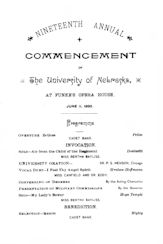
The University of Nebraska held their Nineteenth annual commencement on June 11, 1890. The commencement was held at
Funke’s Opera House which was located at the corner of 12th & O Streets in Lincoln. It had formerly been called Hallo’s Opera House and then Centennial Opera House. According to the
commencement program the Governor attended the ceremony to present the military commissions.

Omaha was also a lot smaller in 1890 with a population of 140,452. The city had a number of paved streets at this time as can be seen on this 1890
Paving map of Omaha, Nebraska. To get a better idea of the physical size of Omaha I studied the map looking for landmarks that are still present 125 years later. The east side of Omaha of course is easy to identify. On the North half of the map
Cut Off Lake is clearly marked. If you don’t recognize that lake it may be because in 1906 the name was changed to Carter Lake. On the South half of the map the Missouri River is clearly marked. The northern edge of town is also fairly easy to identify. Towards the top of the North half of the map you can clearly see Fort Omaha. It’s located near where the top fold line and middle fold line on the map cross.

The south edge of town is also easy to identify. On the bottom right corner of the South half of the map is River View Park. If you don’t know the history of
River View Park it is now the location of the Henry Doorly Zoo. Locating a present day landmark on the far west side of Omaha wasn’t as easy. Looking at the map you will see that there are very few of the north south streets are named and when are named they don’t always match up with current street names. On the South half of the map
Hanscom Park is located at about the center of the map. The west side of the park runs along 32nd Ave. I’m guessing the west side of town ends around what is now 50th street.

Looking at the map you can see that the streets of Omaha in 1890 were paved with a variety of different materials, including sheet asphalt, Sioux Falls granite, Colorado sandstone, Woodruff sandstone, Galesburg brick, cedar block, and cypress block. Looking at the area of 13th and Jones Street you can see that a variety of these options were used in this area. While the map does not label individual stores we know that
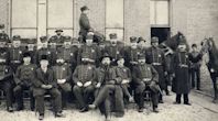
Henry Moeller’s grocery store was located on the northwest corner of 13th and Jones.

Looking at the picture I think the store faced Jones Street but unfortunately I can’t tell if that is Sioux Falls granite in front of the store.
Watch for Nebraska 125 Years Ago, Part 2 next week to see more of Nebraska and what it looked in 1890.
Visit
Nebraska Memories to search for or browse through many more historical images digitized from photographs, negatives, postcards, maps, lantern slides, books and other materials.
Nebraska Memories is a cooperative project to digitize Nebraska-related historical and cultural heritage materials and make them available to researchers of all ages via the Internet. Nebraska Memories is brought to you by the Nebraska Library Commission. If your institution is interested in participating in Nebraska Memories, see
http://nlc.nebraska.gov/nebraskamemories/participation.aspx for more information, contact
Devra Dragos, Technology & Access Services Director.

