Shaka. This week I will show you an
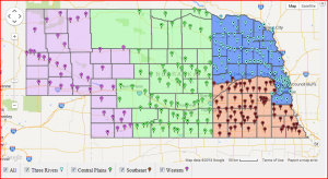
interactive map of the new library systems. This map illustrates the new systems and has markers for each library. You can filter the markers (see the legend at the bottom) by system. If you click on an individual marker, you will get a pop-up box that tells you the name of the library, its system, service population, and a link to more information about it from the NLC website. If you click on any of the dead space within the map, you will get a pop-up indicating what Nebraska County you clicked on and a link to the website for the corresponding system. There is also a small arrow in the upper-right hand corner. If you click on that, it expands a list of the libraries by library name. Please let me know if you have any questions or notice any errors.
 Shaka. This week I will show you an interactive map of the new library systems. This map illustrates the new systems and has markers for each library. You can filter the markers (see the legend at the bottom) by system. If you click on an individual marker, you will get a pop-up box that tells you the name of the library, its system, service population, and a link to more information about it from the NLC website. If you click on any of the dead space within the map, you will get a pop-up indicating what Nebraska County you clicked on and a link to the website for the corresponding system. There is also a small arrow in the upper-right hand corner. If you click on that, it expands a list of the libraries by library name. Please let me know if you have any questions or notice any errors.
