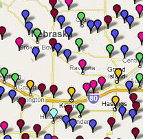
The Library Commission has developed a "map mashup" of public libraries in the state at [obsolete link removed]. Map markers are color-coded to indentify libraries by population served, which enables the user to visualize how libraries of varying sizes are distributed across the state. Clicking on a marker brings up an "info bubble" containing brief statistical data, service measures, and legislative district. A web link within each bubble also connects to the NLC's Library Database entry for the selected location. When searching the map, it is possible to filter out individual population ranges so that only the libraries pertinent to your interest show up. Data for each library is based on the results of the 2006-2007 Public Library Statistical Survey and will be updated as new survey results become available.

